


The Seward Highway: A Road Guide
The Kenai Peninsula's lifeline is the road from Anchorage, a 127-mile drive to Seward on a good two-lane highway, mostly through public land without development or services. Hwy. 1, commonly known as the Seward Highway, is more than scenic -- it's really a wonderful attraction in itself, designated a National Scenic Byway and an All-American Road. Excellent campgrounds and hiking trails are all along the way in the Chugach National Forest.
The mileposts start in Seward. Here we count backward, since you'll likely start from Anchorage.
Mile 127-79 -- The highway begins at the south end of Anchorage, the only way out of town in that direction, and runs along Turnagain Arm to the Portage Glacier.
Mile 79-75 -- Beyond the Portage Glacier turnoff, the road traverses the salt marshes to the south side of the Arm. These wetlands are good bird-watching grounds. The area was inundated in the 1964 earthquake, when the entire region shifted, lowering this area 12 feet and raising areas to the east as much as 38 feet. Everything moved laterally, too, up to 60 feet. People who were here tell of their surprise when the tide came far higher than they had seen it before in the days after the quake, until they realized that the land itself had sunk. Large parts of Homer, Hope, and Seldovia disappeared under the waves at high tide. Seward, Whittier, Valdez, and Kodiak were swept by destructive tsunami waves.
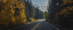
Mile 75-68 -- The highway steeply climbs through the spruce forest to the fresh, towering alpine terrain of the 1,000-foot-elevation Turnagain Pass. The vistas are stupendous year-round. At mile 68, if you feel the urge to walk among the meadow and tundra, park at the pullout with the toilets on the right side at the pass summit and follow the path, or amble off into the wildflowers (assuming the ground is dry). In winter and spring, this is a backcountry skiing and snowmobiling paradise. Skiers go on the left (east) side of the road and snowmobilers on the right. Always check with the Chugach National Forest for avalanche conditions first. Avalanches have taken lives here more than once.
Mile 68-57 -- The pass forms a divide; crossing it, Granite Creek flows down toward the south. The road follows, falling back below the tree line of stunted spruce and then popping back up into sweeping views. Arcing to the northwest after the Granite Creek Campground, the highway follows another north-flowing river, Sixmile Creek. At mile 57, the Hope Highway divides off to the north and west along Sixmile Creek, while the Seward Highway continues south.
Mile 57-46 -- The Seward Highway climbs steeply from the Hope Highway intersection, up the canyon of Canyon Creek, before leveling out above the tree line at about 1,400 feet elevation. At mile 46, Upper Summit Lake lies smooth and reflective in a steep alpine valley. On the far side is Tenderfoot Creek Campground, a calming spot warmed by sun off the water. On the near side, Summit Lake Lodge (tel. 907/244-2031; www.summitlakelodge.com) is a traditional log roadhouse that's been updated to house a modern restaurant. Meals can take some time, so eat here if you're not in a rush. If you don't want dinner, you can enjoy ice cream from the counter in the log gift shop while you stroll near the lake. The lodge rents six motel rooms ($125 double) with private bathrooms, but without TVs or phones.
Mile 46-37 -- The highway continues through similar mountain terrain before descending into the trees again and branching at Tern Lake. This is a stirringly beautiful spot year-round, and a good place to get out and taste the fresh mountain air and watch for moose, waterfowl, and other birds. A 13-site picnic area is to the right at the intersection.
Mile 36 -- Look on the right to turn for the luxurious Inn at Tern Lake (tel. 907/288-3667; www.ternlakeinn.com), a lodge surrounded by mountains and hiking opportunities with four airy, well-made rooms overlooking a pond. The inn has many amenities, including an on-site fishing guide, Chugach Backcountry Fishing. This is a place to spend a few days of quiet, as you'd be too sorry to leave if you stopped only overnight. Summer rates are $175 to $200 double, winter $100.
Mile 32 -- Moose Creek has a viewing platform to watch thousands of spawning salmon, in season; half a mile on, the Trail Lake Fish Hatchery sits on the edge of Upper Trail Lake. This is the first of a string of sparkling mountain lakes that the road will follow for the next 15 miles.
Mile 18-0 -- Down among the big spruces of the coastal forest, the highway comes to Seward.
Note: This information was accurate when it was published, but can change without notice. Please be sure to confirm all rates and details directly with the companies in question before planning your trip.